Sutton Map, Satellite view of Sutton, Berkshire, England
Sutton is located in Berkshire County, Slough, South East, England, United Kingdom.
Location informations of Sutton
Latitude of city of Sutton is 51.49527 and longitude of city of Sutton is -0.53060. Sutton has 1 postcode / zip code, in county of Berkshire.The County of Sutton is Berkshire.
Postcode / zip code of Sutton
SL3 8Administrative division of Sutton
County :BerkshireGPS coordinates of Sutton
Latitude : 51.49527Longitude : -0.53060
Online Map of Sutton - road map, satellite view and street view
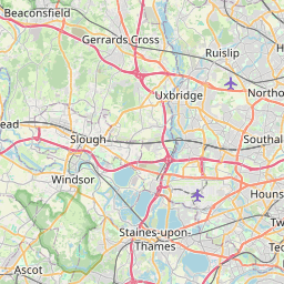

Leaflet | © OpenStreetMap contributors
Search distance between two cities
The weather for Sutton in the United Kingdom
Get today and tomorrow's weather forecasts for Sutton. Find out the weather forecast for the week ahead and the weekend for Sutton in the UK.Sutton weather forecast 15 days
What is the nearest train station to Sutton?
List of Railway Stations near to SuttonThe nearest railway stations to Sutton are listed below. Tickets are available at the train station ticket office or ticket machines.
| Name | Distances from Sutton |
|---|---|
| Langley Station | 1.62 Km |
| Iver Station | 2.21 Km |
| Sunnymeads Station | 3.42 Km |
| Datchet Station | 3.64 Km |
| Heathrow Terminal 5 Station | 3.94 Km |
| Wraysbury Station | 4.25 Km |
| West Drayton Station | 4.36 Km |
| Slough Station | 4.60 Km |
| Windsor and Eton Riverside Station | 5.37 Km |
| Windsor and Eton Central Station | 5.68 Km |
London Heathrow Airport , UK (5.49 Km)
RAF Northolt , UK (10.09 Km)
What is the nearest Public Transport Stops to Sutton?
List of Stops near to SuttonGetting there by public transport (nearest train, tube, overground line station and bus stops). The nearest stops to Sutton are listed below.
| Stop Name | Distances from Sutton |
|---|---|
| Axis Park Bus Stop (E-bound) | 116 m |
| Sutton Court Farm Bus Stop (o/s) | 147 m |
| Sutton Court Farm Bus Stop (opp) | 171 m |
| Parlaunt Flats Bus Stop (nr) | 520 m |
| Parlaunt Flats Bus Stop (opp) | 573 m |
| Sutton Lane North Bus Stop (S-bound) | 596 m |
| Sutton Lane North Bus Stop (N-bound) | 604 m |
| Humber Way Bus Stop (opp) | 606 m |
| Market Lane Bus Stop (opp) | 628 m |
| Humber Way Bus Stop (adj) | 633 m |
Historic Places to Visit near Sutton
List of Historic places near to Sutton
| Name | Distances from Sutton |
|---|---|
| Windsor Castle | 5.36 Km |
| St Georges Chapel | 5.38 Km |
| Eton College | 5.45 Km |
| Windsor Guildhall | 5.61 Km |
| Runnymede | 6.53 Km |
| London Motor Museum | 7.67 Km |
| Great Fosters | 8.74 Km |
| Legoland | 8.78 Km |
| Savill Garden | 8.80 Km |
| Dorney Court | 9.37 Km |
| Dorney, St James the Less Church | 9.60 Km |
| Dorneywood Garden | 10.47 Km |
| Bray, St Michaels Church | 11.97 Km |
| Taplow Court | 12.02 Km |
| Osterley Park | 12.47 Km |
| Cliveden | 12.52 Km |
| Jordans Friends Meeting House | 13.46 Km |
| World Rugby Museum | 13.94 Km |
| Stanley Spencer Gallery | 14.22 Km |
| Boston Manor House | 14.70 Km |
| Strawberry Hill House | 14.99 Km |
Cities or Towns near Sutton
List of places near to
| Name | Distance |
|---|---|
| Brands Hill | 1.00 Km |
| Colnbrook | 1.22 Km |
| Langley | 1.38 Km |
| Poyle | 2.05 Km |
| Richings Park | 2.14 Km |
| Shreding Green | 2.58 Km |
| Horton | 2.58 Km |
| Thorney | 2.69 Km |
| Middle Green | 2.76 Km |
| Datchet Common | 3.21 Km |
| Longford | 3.24 Km |
| Iver | 3.24 Km |
| Love Green | 3.24 Km |
| Datchet | 3.55 Km |
| Upton | 3.62 Km |
| George Green | 3.62 Km |
| Sunnymeads | 3.64 Km |
| Harmondsworth | 3.65 Km |
| Little Britain | 4.06 Km |
| Stanwell Moor | 4.14 Km |
| Upton Lea | 4.15 Km |
| Upton Park | 4.18 Km |
| Myrke | 4.18 Km |
| Wexham Court | 4.30 Km |
| Cowley Peachey | 4.41 Km |
| Yiewsley | 4.47 Km |
| West Drayton | 4.50 Km |
| Slough | 4.57 Km |
| Cowley Peachy | 4.60 Km |
| Wraysbury | 4.68 Km |
| Iver Heath | 4.76 Km |
| Stoke Green | 5.17 Km |
| Cowley | 5.19 Km |
| Sipson | 5.20 Km |
| Old Windsor | 5.20 Km |
| Eton | 5.49 Km |
| Stanwell | 5.53 Km |
| Chalvey | 5.55 Km |
| Uxbridge Moor | 5.65 Km |
| Hythe End | 5.68 Km |
| Salt Hill | 5.69 Km |
| Windsor | 5.79 Km |
| Colham Green | 6.02 Km |
| Wexham Street | 6.05 Km |
| Church Lammas | 6.13 Km |
| Langley Corner | 6.13 Km |
| Runnymede | 6.22 Km |
| West Bedfont | 6.56 Km |
| Harlington | 6.60 Km |
| Uxbridge | 6.67 Km |