Clifton Green Map, Satellite view of Clifton Green, Greater Manchester, England
Clifton Green is located in Greater Manchester County, Salford District, North West, England, United Kingdom.
Location informations of Clifton Green
Latitude of city of Clifton Green is 53.52116 and longitude of city of Clifton Green is -2.32234. Clifton Green has 1 postcode / zip code, in county of Greater Manchester.The County of Clifton Green is Greater Manchester.
Postcode / zip code of Clifton Green
M27 8Administrative division of Clifton Green
County :Greater ManchesterGPS coordinates of Clifton Green
Latitude : 53.52116Longitude : -2.32234
Online Map of Clifton Green - road map, satellite view and street view
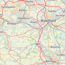

Leaflet | © OpenStreetMap contributors
Search distance between two cities
The weather for Clifton Green in the United Kingdom
Get today and tomorrow's weather forecasts for Clifton Green. Find out the weather forecast for the week ahead and the weekend for Clifton Green in the UK.Clifton Green weather forecast 15 days
What is the nearest train station to Clifton Green?
List of Railway Stations near to Clifton GreenThe nearest railway stations to Clifton Green are listed below. Tickets are available at the train station ticket office or ticket machines.
| Name | Distances from Clifton Green |
|---|---|
| Clifton Station | 523 m |
| Swinton (Greater Manchester) Station | 1.22 Km |
| Moorside Station | 2.02 Km |
| Eccles Station | 4.06 Km |
| Kearsley Station | 4.32 Km |
| Patricroft Station | 4.69 Km |
| Walkden Station | 4.89 Km |
| Salford Crescent Station | 4.93 Km |
| Farnworth Station | 5.39 Km |
| Salford Central Station | 6.15 Km |
City Airport Manchester , UK (7.08 Km)
What is the nearest Public Transport Stops to Clifton Green?
List of Stops near to Clifton GreenGetting there by public transport (nearest train, tube, overground line station and bus stops). The nearest stops to Clifton Green are listed below.
| Stop Name | Distances from Clifton Green |
|---|---|
| Martin Road Bus Stop (Martin Road) | 33 m |
| Martin Road Bus Stop (Martin Road) | 33 m |
| Martin Rd Bus Stop (nr) | 42 m |
| PO Bus Stop (o/s) | 69 m |
| Martin Road Bus Stop (Martin Road) | 139 m |
| Martin Road Bus Stop (Martin Road) | 139 m |
| Whitehead Rd Bus Stop (opp) | 180 m |
| Rake Ln Bus Stop (nr) | 191 m |
| Whitehead Rd Bus Stop (nr) | 213 m |
| Cliveley Avenue Bus Stop (Cliveley Avenue) | 256 m |
Historic Places to Visit near Clifton Green
List of Historic places near to Clifton Green
| Name | Distances from Clifton Green |
|---|---|
| Peoples History Museum | 6.36 Km |
| Bolton, All Souls Church | 10.87 Km |
| Carrington, St Georges Church | 11.75 Km |
| Smithills Hall | 12.68 Km |
Cities or Towns near Clifton Green
List of places near to
| Name | Distance |
|---|---|
| Clifton | 0.04 Km |
| Clifton Junction | 0.55 Km |
| Pendlebury | 0.89 Km |
| Newtown | 1.40 Km |
| Swinton | 1.55 Km |
| Swinton Park | 1.77 Km |
| Deans | 1.90 Km |
| Light Bourne Green | 2.26 Km |
| Wardley | 2.27 Km |
| Park Lane | 2.35 Km |
| Rainsough | 2.48 Km |
| Irlams o' th' Height | 2.56 Km |
| Ringley Fold | 2.56 Km |
| Hazelhurst | 2.69 Km |
| Moorside | 2.70 Km |
| Dales Brow | 2.74 Km |
| Prestwich | 2.78 Km |
| Stand | 2.83 Km |
| Prestwich Bank | 2.87 Km |
| Kersal | 2.94 Km |
| Outwood | 3.07 Km |
| Outwood Gate | 3.12 Km |
| Lower Kersal | 3.16 Km |
| Hilton Park | 3.16 Km |
| Chapel Field | 3.38 Km |
| Besses o' th' Barn | 3.41 Km |
| Broadoak Park | 3.43 Km |
| Brindle Heath | 3.51 Km |
| Whitefield | 3.53 Km |
| Egerton Park | 3.53 Km |
| Ringley | 3.53 Km |
| Kearsley Moss | 3.55 Km |
| Broad Oak | 3.65 Km |
| Stoneclough | 3.68 Km |
| Sedgley Park | 3.70 Km |
| Ellesmere Park | 3.74 Km |
| Heaton Park | 3.77 Km |
| Roe Green | 3.83 Km |
| Oak Bank | 3.85 Km |
| Monton | 3.93 Km |
| Kearsley | 4.03 Km |
| Kirkhams | 4.04 Km |
| Charlestown | 4.06 Km |
| Broughton Park | 4.08 Km |
| Little Bolton | 4.11 Km |
| Whittle Brook | 4.13 Km |
| Kersal Dale | 4.15 Km |
| Linnyshaw | 4.21 Km |
| The Cliff | 4.23 Km |
| HIgher Broughton | 4.31 Km |