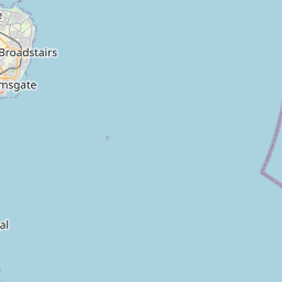
West Cliffe Map, Satellite view of West Cliffe, Kent, England
West Cliffe is located in Kent County, Dover District, South East, England, United Kingdom.
Location informations of West Cliffe
Latitude of city of West Cliffe is 51.15392 and longitude of city of West Cliffe is 1.35736. West Cliffe has 1 postcode / zip code, in county of Kent.The County of West Cliffe is Kent.
Postcode / zip code of West Cliffe
CT15 6Administrative division of West Cliffe
County :KentGPS coordinates of West Cliffe
Latitude : 51.15392Longitude : 1.35736
Online Map of West Cliffe - road map, satellite view and street view
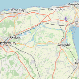
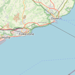


Leaflet | © OpenStreetMap contributors
Search distance between two cities
The weather for West Cliffe in the United Kingdom
Get today and tomorrow's weather forecasts for West Cliffe. Find out the weather forecast for the week ahead and the weekend for West Cliffe in the UK.West Cliffe weather forecast 15 days
What is the nearest train station to West Cliffe?
List of Railway Stations near to West CliffeThe nearest railway stations to West Cliffe are listed below. Tickets are available at the train station ticket office or ticket machines.
| Name | Distances from West Cliffe |
|---|---|
| Martin Mill Station | 1.97 Km |
| Dover Priory Station | 4.80 Km |
| Walmer Station | 5.77 Km |
| Kearsney Station | 5.97 Km |
| Deal Station | 8.21 Km |
| Shepherd's Well Station | 9.68 Km |
| Snowdown Station | 12.12 Km |
| Sandwich Station | 12.94 Km |
| Aylesham Station | 13.14 Km |
| Adisham Station | 14.69 Km |
What is the nearest Public Transport Stops to West Cliffe?
List of Stops near to West CliffeGetting there by public transport (nearest train, tube, overground line station and bus stops). The nearest stops to West Cliffe are listed below.
| Stop Name | Distances from West Cliffe |
|---|---|
| West Cliffe Church Bus Stop (adj) | 13 m |
| West Cliffe Church Bus Stop (opp) | 14 m |
| Nelson Park Bus Stop (opp) | 879 m |
| Nelson Park Bus Stop (adj) | 894 m |
| The Red Lion Bus Stop (opp) | 903 m |
| The Red Lion Bus Stop (adj) | 917 m |
| The Hope Inn Bus Stop (adj) | 1.08 Km |
| The Hope Inn Bus Stop (opp) | 1.10 Km |
| The Swingate Inn Bus Stop (adj) | 1.50 Km |
| The Swingate Inn Bus Stop (opp) | 1.50 Km |
Historic Places to Visit near West Cliffe
List of Historic places near to West Cliffe
| Name | Distances from West Cliffe |
|---|---|
| South Foreland Lighthouse | 1.87 Km |
| White Cliffs of Dover | 2.73 Km |
| Dover Castle | 3.75 Km |
| Roman Painted House | 4.45 Km |
| Dover Museum | 4.50 Km |
| Knights Templar Church | 5.32 Km |
| Western Heights | 5.39 Km |
| Walmer Castle and Gardens | 6.04 Km |
| Waldershare, All Saints Church | 6.17 Km |
| Deal Castle | 7.97 Km |
| Kent Museum of the Moving Image | 8.42 Km |
| Barfreston, St Nicholas Church | 10.23 Km |
| Capel-le-Ferme, St Marys Church | 10.33 Km |
| Knowlton, St Clements Church | 11.06 Km |
| St Johns Commandery | 11.66 Km |
| Sandwich, St Clements Church | 13.36 Km |
| Sandwich, St Peters Church | 13.40 Km |
| The Secret Gardens of Sandwich | 13.48 Km |
| Sandwich, St Marys Church | 13.72 Km |
Cities or Towns near West Cliffe
List of places near to
| Name | Distance |
|---|---|
| St Margaret's at Cliffe | 0.98 Km |
| Martin Mill | 1.88 Km |
| East Langdon | 2.01 Km |
| Martin | 2.46 Km |
| Guston | 2.63 Km |
| Pineham | 3.41 Km |
| West Langdon | 3.45 Km |
| Ringwould | 3.60 Km |
| Church Whitfield | 3.99 Km |
| Buckland Valley | 4.29 Km |
| Napchester | 4.36 Km |
| Kingsdown | 4.40 Km |
| Dover | 4.46 Km |
| Buckland | 4.56 Km |
| Sutton | 4.62 Km |
| Whitfield | 4.74 Km |
| St Radigund's | 4.92 Km |
| Tower Hamlets | 5.12 Km |
| Ripple | 5.15 Km |
| Clarendon | 5.21 Km |
| Western Heights | 5.28 Km |
| Crabble | 5.42 Km |
| Studdal | 5.55 Km |
| East Studdal | 5.67 Km |
| Upper Walmer | 5.68 Km |
| Ashley | 5.72 Km |
| Elms Vale | 5.74 Km |
| River | 5.75 Km |
| Kearsney | 5.78 Km |
| Maxton | 6.09 Km |
| Temple Ewell | 6.11 Km |
| Aycliff | 6.25 Km |
| Walmer | 6.35 Km |
| Little Mongeham | 6.36 Km |
| Mill Hill | 6.38 Km |
| Great Mongeham | 6.78 Km |
| Farthingloe | 6.91 Km |
| Upper Deal | 7.17 Km |
| Lower Walmer | 7.26 Km |
| Northbourne | 7.52 Km |
| Middle Deal | 7.78 Km |
| Eythorne | 7.86 Km |
| Sholden | 7.88 Km |
| Upper Eythorne | 7.94 Km |
| Little Betteshanger | 7.97 Km |
| Tilmanstone | 8.01 Km |
| Lydden | 8.07 Km |
| Coldred | 8.19 Km |
| Deal | 8.21 Km |
| Lower Eythorne | 8.33 Km |