Stanks Map, Satellite view of Stanks, West Yorkshire, England
Stanks is located in West Yorkshire County, Leeds District, Yorkshire and the Humber, England, United Kingdom.
Location informations of Stanks
Latitude of city of Stanks is 53.81578 and longitude of city of Stanks is -1.43914. Stanks has 1 postcode / zip code, in county of West Yorkshire.The County of Stanks is West Yorkshire.
Postcode / zip code of Stanks
LS14 5Administrative division of Stanks
County :West YorkshireGPS coordinates of Stanks
Latitude : 53.81578Longitude : -1.43914
Online Map of Stanks - road map, satellite view and street view
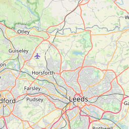

Leaflet | © OpenStreetMap contributors
Search distance between two cities
The weather for Stanks in the United Kingdom
Get today and tomorrow's weather forecasts for Stanks. Find out the weather forecast for the week ahead and the weekend for Stanks in the UK.Stanks weather forecast 15 days
What is the nearest train station to Stanks?
List of Railway Stations near to StanksThe nearest railway stations to Stanks are listed below. Tickets are available at the train station ticket office or ticket machines.
| Name | Distances from Stanks |
|---|---|
| Cross Gates Station | 1.46 Km |
| Garforth Station | 4.30 Km |
| East Garforth Station | 5.22 Km |
| Woodlesford Station | 6.56 Km |
| Leeds Station | 7.49 Km |
| Micklefield Station | 7.96 Km |
| Burley Park Station | 9.11 Km |
| Headingley Station | 10.18 Km |
| Cottingley Station | 11.12 Km |
| Castleford Station | 11.61 Km |
Sherburn-In-Elmet Airfield , UK (14.91 Km)
What is the nearest Public Transport Stops to Stanks?
List of Stops near to StanksGetting there by public transport (nearest train, tube, overground line station and bus stops). The nearest stops to Stanks are listed below.
Historic Places to Visit near Stanks
List of Historic places near to Stanks
| Name | Distances from Stanks |
|---|---|
| Temple Newsam House | 3.74 Km |
| Leeds, St John the Evangelist | 6.94 Km |
| Bramham Park | 7.56 Km |
| Lead, St Marys Church | 9.42 Km |
| Harewood House | 10.70 Km |
| Harewood, All Saints | 10.72 Km |
| Steeton Hall Gateway | 12.09 Km |
Cities or Towns near Stanks
List of places near to
| Name | Distance |
|---|---|
| Swarcliffe | 0.54 Km |
| Manston | 0.60 Km |
| Penda's Fields | 0.70 Km |
| The Green | 1.33 Km |
| Brianside | 1.36 Km |
| Scholes | 1.58 Km |
| Cross Gates | 1.58 Km |
| Whinmoor | 1.83 Km |
| Austhorpe | 1.85 Km |
| The Oval | 1.97 Km |
| Brooklands | 2.02 Km |
| Whitkirk Lane End | 2.05 Km |
| Parklands | 2.11 Km |
| Arthursdale | 2.19 Km |
| Whitkirk | 2.24 Km |
| Seacroft | 2.26 Km |
| Beechwood | 2.28 Km |
| Brown Moor | 2.33 Km |
| Graveleythorpe | 2.46 Km |
| Colton | 2.48 Km |
| Barnbow Carr | 2.61 Km |
| Colton Common | 2.64 Km |
| Killingbeck | 2.90 Km |
| Monkswood | 2.90 Km |
| Fearnville | 3.04 Km |
| Sandhills | 3.13 Km |
| Halton | 3.14 Km |
| Wellington Hill | 3.33 Km |
| Hollin Park | 3.33 Km |
| Barwick in Elmet | 3.45 Km |
| Swillington Common | 3.65 Km |
| Halton Moor | 3.65 Km |
| Gipton | 3.85 Km |
| Moor Garforth | 3.94 Km |
| Oakwood | 4.01 Km |
| Hollinthorpe | 4.06 Km |
| Roundhay | 4.22 Km |
| Lady Wood | 4.24 Km |
| Garforth | 4.25 Km |
| Lidgett | 4.29 Km |
| Gipton Wood | 4.36 Km |
| West Garforth | 4.43 Km |
| Potterton | 4.52 Km |
| Osmondthorpe | 4.52 Km |
| East Garforth | 4.70 Km |
| Harehills | 4.71 Km |
| Church Garforth | 4.72 Km |
| Thorner | 4.85 Km |
| Kiddal Lane End | 4.96 Km |
| Harehills Corner | 5.11 Km |