Rushmere Map, Satellite view of Rushmere, Suffolk, England
Rushmere is located in Suffolk County, Waveney District, Eastern, England, United Kingdom.
Location informations of Rushmere
Latitude of city of Rushmere is 52.42385 and longitude of city of Rushmere is 1.66490. Rushmere has 1 postcode / zip code, in county of Suffolk.The County of Rushmere is Suffolk.
Postcode / zip code of Rushmere
NR33 8Administrative division of Rushmere
County :SuffolkGPS coordinates of Rushmere
Latitude : 52.42385Longitude : 1.66490
Online Map of Rushmere - road map, satellite view and street view
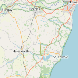


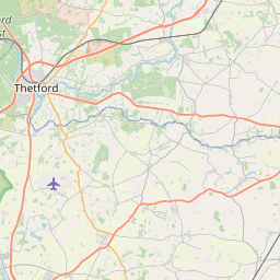


Leaflet | © OpenStreetMap contributors
Search distance between two cities
The weather for Rushmere in the United Kingdom
Get today and tomorrow's weather forecasts for Rushmere. Find out the weather forecast for the week ahead and the weekend for Rushmere in the UK.Rushmere weather forecast 15 days
What is the nearest train station to Rushmere?
List of Railway Stations near to RushmereThe nearest railway stations to Rushmere are listed below. Tickets are available at the train station ticket office or ticket machines.
| Name | Distances from Rushmere |
|---|---|
| Oulton Broad South Station | 5.85 Km |
| Oulton Broad North Station | 6.91 Km |
| Beccles Station | 7.53 Km |
| Lowestoft Station | 8.04 Km |
| Brampton (Suffolk) Station | 8.80 Km |
| Somerleyton Station | 9.64 Km |
| Haddiscoe Station | 12.01 Km |
| Halesworth Station | 13.79 Km |
| Reedham (Norfolk) Station | 17.19 Km |
| Berney Arms Station | 18.60 Km |
Beccles Airport , UK (3.40 Km)
What is the nearest Public Transport Stops to Rushmere?
List of Stops near to RushmereGetting there by public transport (nearest train, tube, overground line station and bus stops). The nearest stops to Rushmere are listed below.
| Stop Name | Distances from Rushmere |
|---|---|
| Rushmere Corner Bus Stop (opp) | 18 m |
| Rushmere Corner Bus Stop (adj) | 19 m |
| Crossroads Bus Stop (S-bound) | 967 m |
| Crossroads Bus Stop (W-bound) | 974 m |
| Crossroads Bus Stop (E-bound) | 974 m |
| Crossroads Bus Stop (N-bound) | 1.01 Km |
| Church Bus Stop (adj) | 1.08 Km |
| Church Bus Stop (opp) | 1.09 Km |
| Village Hall Bus Stop (adj) | 1.35 Km |
| Village Hall Bus Stop (opp) | 1.36 Km |
Historic Places to Visit near Rushmere
List of Historic places near to Rushmere
| Name | Distances from Rushmere |
|---|---|
| Gisleham, Holy Trinity Church | 2.68 Km |
| Sotterley, St Margarets Church | 3.74 Km |
| Ellough, All Saints Church | 5.06 Km |
| Covehithe, St Andrews Church | 5.91 Km |
| Westhall, St Andrews Church | 9.51 Km |
| Somerleyton, St Marys Church | 10.24 Km |
| Southwold, St Edmunds Church | 10.67 Km |
| Somerleyton Hall and Gardens | 10.80 Km |
| Herringfleet, St Margarets Church | 11.14 Km |
| Walberswick, St Andrews Church | 12.23 Km |
| Blyford, All Saints Church | 12.24 Km |
| Halesworth Airfield Museum | 12.25 Km |
| Blythburgh, Holy Trinity Church | 12.33 Km |
| Holton, St Peters Church | 12.82 Km |
| St Olaves Priory | 12.92 Km |
| Holton Post Mill | 13.09 Km |
| Spexhall, St Peters Church | 13.25 Km |
| Wenhaston, St Peters Church | 13.28 Km |
| Raveningham Hall | 13.31 Km |
| Raveningham, St Andrews Church | 13.35 Km |
| Hales Church | 14.23 Km |
| Halesworth, St Marys Church | 14.27 Km |
| Thorington, St Peters Church | 14.56 Km |
| Wissett, St Andrews Church | 14.77 Km |
Cities or Towns near Rushmere
List of places near to
| Name | Distance |
|---|---|
| Henstead | 1.00 Km |
| Toad Row | 1.19 Km |
| Mutford | 1.36 Km |
| Black Street | 2.18 Km |
| Hulver Street | 2.40 Km |
| Gisleham | 2.63 Km |
| Benacre | 3.18 Km |
| Barnby | 3.20 Km |
| Kessingland | 3.30 Km |
| North Cove | 3.40 Km |
| Wrentham West End | 3.57 Km |
| Carlton Colville | 3.63 Km |
| Cuckold's Green | 4.17 Km |
| West End | 4.34 Km |
| Wrentham | 4.36 Km |
| Kessingland Beach | 4.46 Km |
| Sotterley | 4.80 Km |
| Pakefield | 4.98 Km |
| Ellough | 4.98 Km |
| Worlingham | 5.69 Km |
| Frostenden | 5.88 Km |
| Covehithe | 5.90 Km |
| Willingham | 6.01 Km |
| South Cove | 6.18 Km |
| Weston | 6.24 Km |
| Clay Common | 6.31 Km |
| Kirkley | 6.45 Km |
| Shadingfield | 6.47 Km |
| Frostenden Corner | 6.51 Km |
| Oulton Broad | 6.76 Km |
| Stoven | 6.94 Km |
| Burgh St Peter | 7.08 Km |
| Cove Bottom | 7.13 Km |
| Hog's Corner | 7.14 Km |
| Barnaby Green | 7.29 Km |
| Camps Heath | 7.40 Km |
| Brampton | 7.41 Km |
| Wheatacre | 7.59 Km |
| Normanston | 7.76 Km |
| Beccles | 7.91 Km |
| Aldeby | 7.93 Km |
| Ringsfield Common | 8.16 Km |
| Wangford | 8.21 Km |
| Ringsfield Corner | 8.22 Km |
| Uggeshall | 8.27 Km |
| Brampton Street | 8.28 Km |
| Lowestoft | 8.31 Km |
| Roman Hill | 8.32 Km |
| Oulton | 8.37 Km |
| Redisham | 8.69 Km |