New Brighton Map, Satellite view of New Brighton, West Yorkshire, England
New Brighton is located in West Yorkshire County, Wakefield District, Yorkshire and the Humber, England, United Kingdom.
Location informations of New Brighton
Latitude of city of New Brighton is 53.67803 and longitude of city of New Brighton is -1.50870. New Brighton has 1 postcode / zip code, in county of West Yorkshire.The County of New Brighton is West Yorkshire.
Postcode / zip code of New Brighton
WF2 9Administrative division of New Brighton
County :West YorkshireGPS coordinates of New Brighton
Latitude : 53.67803Longitude : -1.50870
Online Map of New Brighton - road map, satellite view and street view
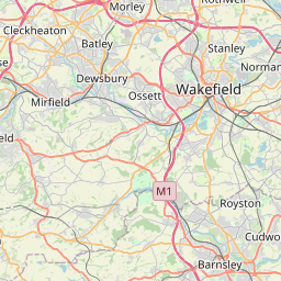

Leaflet | © OpenStreetMap contributors
Search distance between two cities
The weather for New Brighton in the United Kingdom
Get today and tomorrow's weather forecasts for New Brighton. Find out the weather forecast for the week ahead and the weekend for New Brighton in the UK.New Brighton weather forecast 15 days
What is the nearest train station to New Brighton?
List of Railway Stations near to New BrightonThe nearest railway stations to New Brighton are listed below. Tickets are available at the train station ticket office or ticket machines.
| Name | Distances from New Brighton |
|---|---|
| Wakefield Westgate Station | 586 m |
| Wakefield Kirkgate Station | 1.33 Km |
| Sandal And Agbrigg Station | 2.45 Km |
| Outwood Station | 4.14 Km |
| Normanton Station | 6.15 Km |
| Streethouse Station | 7.15 Km |
| Batley Station | 8.32 Km |
| Dewsbury Station | 8.34 Km |
| Morley Station | 9.66 Km |
| Ravensthorpe Station | 9.68 Km |
What is the nearest Public Transport Stops to New Brighton?
List of Stops near to New BrightonGetting there by public transport (nearest train, tube, overground line station and bus stops). The nearest stops to New Brighton are listed below.
Historic Places to Visit near New Brighton
List of Historic places near to New Brighton
| Name | Distances from New Brighton |
|---|---|
| Sandal Castle | 2.38 Km |
| National Coal Mining Museum for England | 8.21 Km |
| Nostell Priory | 8.42 Km |
| Bagshaw Museum | 10.55 Km |
| Temple Newsam House | 12.26 Km |
| Pontefract Castle | 13.69 Km |
| Leeds, St John the Evangelist | 13.76 Km |
| Monk Bretton Priory | 14.51 Km |
Cities or Towns near New Brighton
List of places near to
| Name | Distance |
|---|---|
| Clayton Hill | 0.15 Km |
| Brooks Bank | 0.26 Km |
| Westgate Common | 0.52 Km |
| Borough Corner | 0.87 Km |
| St Johns | 0.88 Km |
| New Scarborough | 0.90 Km |
| Wakefield | 0.94 Km |
| Thornes | 0.95 Km |
| Primrose Hill | 1.23 Km |
| Flanshaw | 1.33 Km |
| Fall Ings | 1.56 Km |
| Belle Isle | 1.57 Km |
| Calder Vale | 1.86 Km |
| Lupset | 1.96 Km |
| Belle Vue | 1.97 Km |
| Portobello | 2.00 Km |
| Park Hill | 2.08 Km |
| East Moor | 2.10 Km |
| Alverthorpe | 2.29 Km |
| Agbrigg | 2.35 Km |
| Snow Hill | 2.35 Km |
| Pinders Fields | 2.38 Km |
| Sandal | 2.45 Km |
| Newton Hill | 2.58 Km |
| Wrenthorpe | 2.81 Km |
| Sandal Magna | 2.87 Km |
| Spring End | 2.98 Km |
| Heath | 2.98 Km |
| Ossett Spa | 3.04 Km |
| Heath Common | 3.04 Km |
| Milnthorpe | 3.05 Km |
| Durkar | 3.07 Km |
| Low Common | 3.24 Km |
| Haggs Hill | 3.37 Km |
| Hall Cliffe | 3.43 Km |
| Stand Bridge | 3.44 Km |
| Horbury Junction | 3.47 Km |
| Shepherd Hill | 3.56 Km |
| Horbury | 3.60 Km |
| Woolgreaves | 3.67 Km |
| Horse Race End | 3.68 Km |
| Brandy Carr | 3.69 Km |
| Woodthorpe | 3.74 Km |
| Outwood | 3.77 Km |
| Kettlethorpe | 3.84 Km |
| Kirkhamgate | 3.91 Km |
| Kirkthorpe | 3.95 Km |
| Calder Grove | 3.99 Km |
| South Ossett | 4.07 Km |
| Pledwick | 4.07 Km |