Netherthorpe Map, Satellite view of Netherthorpe, Derbyshire, England
Netherthorpe is located in Derbyshire County, Chesterfield District, East Midlands, England, United Kingdom.
Location informations of Netherthorpe
Latitude of city of Netherthorpe is 53.26702 and longitude of city of Netherthorpe is -1.33957. Netherthorpe has 1 postcode / zip code, in county of Derbyshire.The County of Netherthorpe is Derbyshire.
Postcode / zip code of Netherthorpe
S43 3Administrative division of Netherthorpe
County :DerbyshireGPS coordinates of Netherthorpe
Latitude : 53.26702Longitude : -1.33957
Online Map of Netherthorpe - road map, satellite view and street view
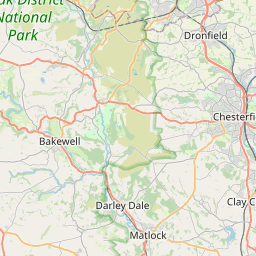

Leaflet | © OpenStreetMap contributors
Search distance between two cities
The weather for Netherthorpe in the United Kingdom
Get today and tomorrow's weather forecasts for Netherthorpe. Find out the weather forecast for the week ahead and the weekend for Netherthorpe in the UK.Netherthorpe weather forecast 15 days
What is the nearest train station to Netherthorpe?
List of Railway Stations near to NetherthorpeThe nearest railway stations to Netherthorpe are listed below. Tickets are available at the train station ticket office or ticket machines.
| Name | Distances from Netherthorpe |
|---|---|
| Chesterfield Station | 6.24 Km |
| Creswell (Derbys) Station | 8.20 Km |
| Whitwell (Derbys) Station | 9.38 Km |
| Dronfield Station | 9.40 Km |
| Langwith Station | 9.51 Km |
| Kiveton Bridge Station | 9.53 Km |
| Kiveton Park Station | 10.20 Km |
| Woodhouse Station | 10.82 Km |
| Shirebrook (Derbys) Station | 11.49 Km |
| Shireoaks Station | 13.09 Km |
Sheffield City Heliport , UK (14.52 Km)
What is the nearest Public Transport Stops to Netherthorpe?
List of Stops near to NetherthorpeGetting there by public transport (nearest train, tube, overground line station and bus stops). The nearest stops to Netherthorpe are listed below.
| Stop Name | Distances from Netherthorpe |
|---|---|
| Netherthorpe School Bus Stop (Adj) | 204 m |
| Ralph Road Bus Stop (opp) | 277 m |
| Ralph Road Bus Stop (adj) | 279 m |
| Whitehead Street Bus Stop (Adj) | 286 m |
| Moor View Road Bus Stop (Opp) | 290 m |
| Whitehead Street Bus Stop (Opp) | 301 m |
| The Speedwell Bus Stop (Opp) | 405 m |
| Ireland Close Bus Stop (Opp) | 426 m |
| Ireland Close Bus Stop (Adj) | 452 m |
| Lowgates Bus Stop (E-bound) | 497 m |
Historic Places to Visit near Netherthorpe
List of Historic places near to Netherthorpe
| Name | Distances from Netherthorpe |
|---|---|
| Renishaw Hall | 4.01 Km |
| Bolsover Cundy House | 4.77 Km |
| Bolsover Castle | 4.87 Km |
| Revolution House | 5.74 Km |
| Sutton Scarsdale Hall | 5.94 Km |
| Chesterfield, Crooked Spire Church | 6.65 Km |
| Hardwick Hall | 9.65 Km |
| Stainsby Mill | 11.11 Km |
| Hardwick Old Hall | 11.32 Km |
| Beauchief Abbey | 13.01 Km |
Cities or Towns near Netherthorpe
List of places near to
| Name | Distance |
|---|---|
| Lowgates | 0.43 Km |
| Woodthorpe | 0.87 Km |
| Poolsbrook | 0.91 Km |
| Staveley | 0.91 Km |
| Mastin Moor | 1.70 Km |
| Duckmanton | 2.33 Km |
| Middlecroft | 2.35 Km |
| Barrow Hill | 2.37 Km |
| Inkersall Green | 2.59 Km |
| Hollingwood | 2.64 Km |
| Inkersall | 2.70 Km |
| Emmett Carr | 2.91 Km |
| Markham Vale | 3.04 Km |
| Shuttlewood | 3.14 Km |
| Long Duckmanton | 3.17 Km |
| Bolsover Woodhouse | 3.24 Km |
| Renishaw | 3.29 Km |
| New Brimington | 3.32 Km |
| Stanfree | 3.34 Km |
| Arkwright Town | 3.85 Km |
| Brimington | 3.98 Km |
| Oxcroft | 4.09 Km |
| Nether Handley | 4.16 Km |
| Brimington Common | 4.20 Km |
| Spinkhill | 4.21 Km |
| Barlborough | 4.27 Km |
| Oxcroft Estate | 4.34 Km |
| New Whittington | 4.49 Km |
| Limekiln Field | 4.67 Km |
| New Bolsover | 4.80 Km |
| Eckington | 4.85 Km |
| Middle Handley | 4.87 Km |
| Bolehill | 4.98 Km |
| Calow | 4.98 Km |
| Clowne | 5.05 Km |
| West Handley | 5.32 Km |
| Tapton | 5.33 Km |
| Cock Alley | 5.34 Km |
| Bolsover | 5.35 Km |
| Carr Vale | 5.36 Km |
| Westthorpe | 5.38 Km |
| Harlesthorpe | 5.65 Km |
| Old Whittington | 5.66 Km |
| Hady | 5.70 Km |
| Marsh Lane | 5.74 Km |
| Calow Green | 5.78 Km |
| Upperthorpe | 5.82 Km |
| Whittington Moor | 5.98 Km |
| Sutton Scarsdale | 5.99 Km |
| Bramley | 6.02 Km |