Mill Shaw Map, Satellite view of Mill Shaw, West Yorkshire, England
Mill Shaw is located in West Yorkshire County, Leeds District, Yorkshire and the Humber, England, United Kingdom.
Location informations of Mill Shaw
Latitude of city of Mill Shaw is 53.76592 and longitude of city of Mill Shaw is -1.57510. Mill Shaw has 1 postcode / zip code, in county of West Yorkshire.The County of Mill Shaw is West Yorkshire.
Postcode / zip code of Mill Shaw
LS11 8Administrative division of Mill Shaw
County :West YorkshireGPS coordinates of Mill Shaw
Latitude : 53.76592Longitude : -1.57510
Online Map of Mill Shaw - road map, satellite view and street view
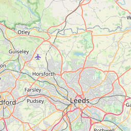
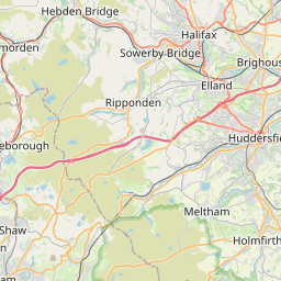

Leaflet | © OpenStreetMap contributors
Search distance between two cities
The weather for Mill Shaw in the United Kingdom
Get today and tomorrow's weather forecasts for Mill Shaw. Find out the weather forecast for the week ahead and the weekend for Mill Shaw in the UK.Mill Shaw weather forecast 15 days
What is the nearest train station to Mill Shaw?
List of Railway Stations near to Mill ShawThe nearest railway stations to Mill Shaw are listed below. Tickets are available at the train station ticket office or ticket machines.
| Name | Distances from Mill Shaw |
|---|---|
| Cottingley Station | 855 m |
| Morley Station | 2.06 Km |
| Leeds Station | 3.75 Km |
| Burley Park Station | 5.13 Km |
| Headingley Station | 5.92 Km |
| Bramley (West Yorkshire) Station | 5.99 Km |
| Batley Station | 6.97 Km |
| Outwood Station | 7.06 Km |
| Kirkstall Forge Station | 7.14 Km |
| New Pudsey Station | 8.16 Km |
Leeds Bradford Airport , UK (12.45 Km)
What is the nearest Public Transport Stops to Mill Shaw?
List of Stops near to Mill ShawGetting there by public transport (nearest train, tube, overground line station and bus stops). The nearest stops to Mill Shaw are listed below.
Historic Places to Visit near Mill Shaw
List of Historic places near to Mill Shaw
| Name | Distances from Mill Shaw |
|---|---|
| Leeds, St John the Evangelist | 4.41 Km |
| Bagshaw Museum | 6.19 Km |
| Temple Newsam House | 7.86 Km |
| National Media Museum | 12.21 Km |
| Colour Experience | 12.50 Km |
| Sandal Castle | 13.08 Km |
| National Coal Mining Museum for England | 13.89 Km |
| Harewood House | 14.88 Km |
| Harewood, All Saints | 14.90 Km |
Cities or Towns near Mill Shaw
List of places near to
| Name | Distance |
|---|---|
| Beeston | 0.51 Km |
| Churwell | 0.92 Km |
| Beeston Park Side | 1.11 Km |
| Beeston Royds | 1.67 Km |
| Beeston Hill | 1.81 Km |
| Islington | 1.87 Km |
| Daisy Hill | 1.93 Km |
| Far Royds | 2.00 Km |
| Bantam Grove | 2.19 Km |
| Gillroyd | 2.31 Km |
| Holbeck | 2.50 Km |
| Lower Wortley | 2.51 Km |
| Troy Hill | 2.51 Km |
| Well Hill | 2.54 Km |
| Morley | 2.58 Km |
| New Blackpool | 2.60 Km |
| Hunslet Carr | 2.66 Km |
| Burn Knolls | 2.68 Km |
| Middleton | 2.77 Km |
| Town End | 2.79 Km |
| Low Town End | 2.79 Km |
| Morley Hole | 2.80 Km |
| Hunslet | 2.88 Km |
| New Wortley | 2.92 Km |
| Upper Wortley | 3.01 Km |
| New Brighton | 3.04 Km |
| Topcliffe | 3.25 Km |
| Camp Field | 3.33 Km |
| Pottery Field | 3.35 Km |
| New Farnley | 3.39 Km |
| Woodhouse Hill | 3.41 Km |
| Granary Wharf | 3.47 Km |
| Birks | 3.57 Km |
| Low Moor Side | 3.59 Km |
| Carr Crofts | 3.67 Km |
| Atkinson Hill | 3.69 Km |
| Silver Royd Hill | 3.71 Km |
| Armley | 3.78 Km |
| Gildersome | 3.83 Km |
| Farnley | 3.85 Km |
| Gildersome Street | 3.91 Km |
| Thwaite Gate | 3.94 Km |
| Bruntcliffe | 3.96 Km |
| Upper Moor Side | 4.03 Km |
| Tingley | 4.11 Km |
| Steander | 4.14 Km |
| Scott Green | 4.19 Km |
| Leeds | 4.20 Km |
| America Moor | 4.20 Km |
| Black Gates | 4.26 Km |