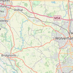
London Fields Map, Satellite view of London Fields, West Midlands, England
London Fields is located in West Midlands County, Dudley District, West Midlands, England, United Kingdom.
Location informations of London Fields
Latitude of city of London Fields is 52.51194 and longitude of city of London Fields is -2.10659. London Fields has 1 postcode / zip code, in county of West Midlands.The County of London Fields is West Midlands.
Postcode / zip code of London Fields
DY1 2Administrative division of London Fields
County :West MidlandsGPS coordinates of London Fields
Latitude : 52.51194Longitude : -2.10659
Online Map of London Fields - road map, satellite view and street view
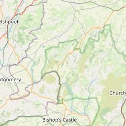

Leaflet | © OpenStreetMap contributors
Search distance between two cities
The weather for London Fields in the United Kingdom
Get today and tomorrow's weather forecasts for London Fields. Find out the weather forecast for the week ahead and the weekend for London Fields in the UK.London Fields weather forecast 15 days
What is the nearest train station to London Fields?
List of Railway Stations near to London FieldsThe nearest railway stations to London Fields are listed below. Tickets are available at the train station ticket office or ticket machines.
| Name | Distances from London Fields |
|---|---|
| Tipton Station | 3.45 Km |
| Coseley Station | 3.95 Km |
| Dudley Port Station | 4.11 Km |
| Cradley Heath Station | 4.83 Km |
| Old Hill Station | 5.69 Km |
| Lye Station | 5.82 Km |
| Rowley Regis Station | 6.41 Km |
| Sandwell and Dudley Station | 6.44 Km |
| Stourbridge Town Station | 6.71 Km |
| Langley Green Station | 7.17 Km |
Wolverhampton Halfpenny Green Airport , UK (10.36 Km)
What is the nearest Public Transport Stops to London Fields?
List of Stops near to London FieldsGetting there by public transport (nearest train, tube, overground line station and bus stops). The nearest stops to London Fields are listed below.
| Stop Name | Distances from London Fields |
|---|---|
| Himley Avenue Bus Stop (opp) | 8 m |
| Himley Avenue Bus Stop (adj) | 33 m |
| Dibdale St Bus Stop (opp) | 243 m |
| Langstone Rd Bus Stop (opp) | 273 m |
| Dibdale St Bus Stop (adj) | 276 m |
| Langstone Rd Bus Stop (adj) | 280 m |
| Post Office Bus Stop (adj) | 325 m |
| Post Office Bus Stop (opp) | 334 m |
| St Barnabus Church Bus Stop (opp) | 432 m |
| Hexham Way Bus Stop (adj) | 434 m |
Historic Places to Visit near London Fields
List of Historic places near to London Fields
| Name | Distances from London Fields |
|---|---|
| Black Country Living Museum | 2.48 Km |
| Bilston Craft Gallery | 6.71 Km |
| Bantock House and Park | 8.36 Km |
| Wolverhampton Art Gallery | 8.46 Km |
| Hagley Hall | 9.79 Km |
| Wightwick Manor | 9.82 Km |
| Moseley Old Hall | 13.97 Km |
| Selly Manor | 14.60 Km |
| Birmingham Back to Backs | 14.79 Km |
Cities or Towns near London Fields
List of places near to
| Name | Distance |
|---|---|
| Eve Hill | 0.64 Km |
| Russell's Hall | 0.82 Km |
| New Dock | 0.85 Km |
| Springs Mire | 0.85 Km |
| Dibdale | 0.85 Km |
| Scott's Green | 1.18 Km |
| Old Dock | 1.20 Km |
| Priory | 1.30 Km |
| Holly Hall | 1.32 Km |
| Wren's Nest | 1.35 Km |
| Blowers Green | 1.47 Km |
| Dudley | 1.60 Km |
| Gornalwood | 1.70 Km |
| Lower Gornal | 1.77 Km |
| Woodside | 1.79 Km |
| Upper Gornal | 1.83 Km |
| Ruiton | 2.08 Km |
| Kates Hill | 2.21 Km |
| Hart's Hill | 2.32 Km |
| Parkes Hall | 2.32 Km |
| Woodsetton | 2.39 Km |
| Baptist End | 2.45 Km |
| Pensnett | 2.52 Km |
| Dixon's Green | 2.53 Km |
| Bramford | 2.68 Km |
| Swan Village | 2.72 Km |
| Tipton Green | 2.85 Km |
| Tansley Hill | 2.87 Km |
| Netherton | 2.90 Km |
| The Straits | 2.97 Km |
| Brockmoor | 3.00 Km |
| Cawney Hill | 3.03 Km |
| Bromley | 3.04 Km |
| The Coppice | 3.10 Km |
| Burnt Tree | 3.20 Km |
| West Coseley | 3.22 Km |
| Primrose Hill | 3.29 Km |
| Sedgley | 3.43 Km |
| Dudley Port | 3.47 Km |
| Roseville | 3.47 Km |
| Oakham | 3.51 Km |
| Tividale Hall | 3.52 Km |
| Hurst Hill | 3.54 Km |
| Bloomfield | 3.58 Km |
| Wallbrook | 3.58 Km |
| Coseley | 3.59 Km |
| Windmill End | 3.62 Km |
| Upper Ettingshall | 3.69 Km |
| Springfield | 3.71 Km |
| Darby End | 3.74 Km |