Hodley Map, Satellite view of Hodley, Powys, Wales
Hodley is located in Powys County, Powys, Wales, Wales, United Kingdom.
Location informations of Hodley
Latitude of city of Hodley is 52.51561 and longitude of city of Hodley is -3.22600. Hodley has 1 postcode / zip code, in county of Powys.The County of Hodley is Powys.
Postcode / zip code of Hodley
SY16 4Administrative division of Hodley
County :PowysGPS coordinates of Hodley
Latitude : 52.51561Longitude : -3.22600
Online Map of Hodley - road map, satellite view and street view
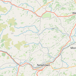


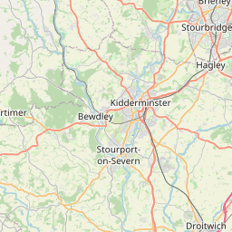

Leaflet | © OpenStreetMap contributors
Search distance between two cities
The weather for Hodley in the United Kingdom
Get today and tomorrow's weather forecasts for Hodley. Find out the weather forecast for the week ahead and the weekend for Hodley in the UK.Hodley weather forecast 15 days
What is the nearest train station to Hodley?
List of Railway Stations near to HodleyThe nearest railway stations to Hodley are listed below. Tickets are available at the train station ticket office or ticket machines.
| Name | Distances from Hodley |
|---|---|
| Newtown Station | 5.79 Km |
| Caersws Station | 13.97 Km |
| Welshpool Station | 16.82 Km |
| Llangynllo Station | 18.97 Km |
| Knucklas Station | 19.40 Km |
| Llanbister Road Station | 19.94 Km |
| Knighton Station | 22.69 Km |
| Dolau Station | 24.62 Km |
| Broome Station | 25.29 Km |
| Hopton Heath Station | 25.36 Km |
What is the nearest Public Transport Stops to Hodley?
List of Stops near to HodleyGetting there by public transport (nearest train, tube, overground line station and bus stops). The nearest stops to Hodley are listed below.
| Stop Name | Distances from Hodley |
|---|---|
| Glanmule Garage Bus Stop | 1.25 Km |
| Glanmiheli Bridge Bus Stop | 1.36 Km |
| Glanmiheli Bridge Bus Stop | 1.36 Km |
| Kerry Lamb Inn Bus Stop | 2.60 Km |
| Herbert Arms Bus Stop | 2.64 Km |
| Herbert Arms Bus Stop | 2.65 Km |
| Bettws Turn Bus Stop | 2.80 Km |
| Bettws Turn Bus Stop | 2.81 Km |
| Bettws Turn Bus Stop | 2.83 Km |
| Bryn-y-maes Bus Stop | 2.89 Km |
Historic Places to Visit near Hodley
List of Historic places near to Hodley
| Name | Distances from Hodley |
|---|---|
| Dolforwyn Castle | 3.84 Km |
| St Marys Church & Robert Owens Grave | 5.99 Km |
| Robert Owen Memorial Museum | 6.00 Km |
| Newtown Hall Castle Motte | 6.16 Km |
| Montgomery Castle | 7.38 Km |
| Montgomery, St Nicholas Church | 7.38 Km |
| Lymore Park | 7.88 Km |
| Forden Gaer Roman Fort | 8.31 Km |
| Glansevern Hall Gardens | 9.15 Km |
| Andrew Logan Museum of Sculpture | 9.30 Km |
| Gregynog Hall & Gardens | 10.32 Km |
| Castell y Blaidd (Wolfs Castle) | 12.54 Km |
| Caersws Roman Forts | 13.90 Km |
| Castle Caereinion Castle | 13.95 Km |
Cities or Towns near Hodley
List of places near to
| Name | Distance |
|---|---|
| Penygelli | 1.08 Km |
| Glanmule | 1.26 Km |
| Llanmerewig | 1.57 Km |
| Brynllywarch | 2.49 Km |
| Ceri / Kerry | 2.65 Km |
| Llancowrid | 2.80 Km |
| Pentre | 2.85 Km |
| Abermule / Aber-miwl | 3.25 Km |
| Sarn | 3.45 Km |
| Brynderwen | 3.95 Km |
| Dôl-forwyn | 4.05 Km |
| Penygelli | 4.06 Km |
| Aberbechan | 4.09 Km |
| New Wells | 4.17 Km |
| Ffridd | 4.17 Km |
| Green Lane | 4.22 Km |
| Llanllwchaiarn | 4.54 Km |
| Penarron | 4.60 Km |
| Llandyssil | 4.64 Km |
| Hopton Uchaf | 5.41 Km |
| Newtown / Y Drenewydd | 6.02 Km |
| Anchor | 6.08 Km |
| Fron | 6.08 Km |
| Plas Meredydd | 6.14 Km |
| Penygloddfa | 6.15 Km |
| Weston Madoc | 6.22 Km |
| Cefn Mawr | 6.47 Km |
| Garth Owen | 6.59 Km |
| Hopton Isaf | 6.75 Km |
| Pentre Llifior | 6.81 Km |
| Trehafren | 6.90 Km |
| Bettws Cedewain | 7.03 Km |
| Trwstllewelyn | 7.11 Km |
| Montgomery / Trefaldwyn | 7.27 Km |
| Maesyrhandir | 7.34 Km |
| Milford | 7.37 Km |
| Garthmyl | 7.39 Km |
| Pentreheyling | 7.48 Km |
| Caerhowel | 7.57 Km |
| Bacheldre | 7.63 Km |
| Nantoer | 7.65 Km |
| Dolfor | 7.69 Km |
| Brooks | 7.98 Km |
| Hendomen | 8.00 Km |
| Stepaside | 8.75 Km |
| Ale Oak | 9.00 Km |
| Pentiken | 9.27 Km |
| Refail | 9.30 Km |
| Berriew / Aberriw | 9.49 Km |
| Crug-y-byddar | 9.55 Km |