Havannah Map, Satellite view of Havannah, Cheshire, England
Havannah is located in Cheshire County, Cheshire East, North West, England, United Kingdom.
Location informations of Havannah
Latitude of city of Havannah is 53.17746 and longitude of city of Havannah is -2.18848. Havannah has 1 postcode / zip code, in county of Cheshire.The County of Havannah is Cheshire.
Postcode / zip code of Havannah
CW12 2Administrative division of Havannah
County :CheshireGPS coordinates of Havannah
Latitude : 53.17746Longitude : -2.18848
Online Map of Havannah - road map, satellite view and street view
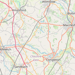
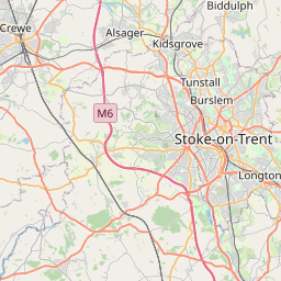

Leaflet | © OpenStreetMap contributors
Search distance between two cities
The weather for Havannah in the United Kingdom
Get today and tomorrow's weather forecasts for Havannah. Find out the weather forecast for the week ahead and the weekend for Havannah in the UK.Havannah weather forecast 15 days
What is the nearest train station to Havannah?
List of Railway Stations near to HavannahThe nearest railway stations to Havannah are listed below. Tickets are available at the train station ticket office or ticket machines.
| Name | Distances from Havannah |
|---|---|
| Congleton Station | 2.20 Km |
| Macclesfield Station | 10.12 Km |
| Goostrey Station | 10.47 Km |
| Kidsgrove Station | 10.78 Km |
| Holmes Chapel Station | 11.10 Km |
| Alsager Station | 11.94 Km |
| Chelford Station | 12.01 Km |
| Prestbury Station | 13.20 Km |
| Sandbach Station | 14.00 Km |
| Alderley Edge Station | 14.41 Km |
What is the nearest Public Transport Stops to Havannah?
List of Stops near to HavannahGetting there by public transport (nearest train, tube, overground line station and bus stops). The nearest stops to Havannah are listed below.
| Stop Name | Distances from Havannah |
|---|---|
| Harvey Road Bus Stop (S-bound) | 291 m |
| Co-op Bus Stop (o/s) | 383 m |
| Co-op Bus Stop (opp) | 394 m |
| Harvey Road Bus Stop (nr) | 470 m |
| Harvey Road Bus Stop (by) | 480 m |
| Harvey Road Bus Stop (cnr) | 531 m |
| Harvey Road Bus Stop (opp) | 535 m |
| Davidson Avenue Bus Stop (opp) | 586 m |
| St John's Road Bus Stop (o/s 70) | 643 m |
| St John's Road Bus Stop (opp 70) | 652 m |
Historic Places to Visit near Havannah
List of Historic places near to Havannah
| Name | Distances from Havannah |
|---|---|
| Congleton Museum | 2.20 Km |
| Astbury, St Marys Church | 4.11 Km |
| Marton, St James and St Pauls Church | 4.29 Km |
| Gawsworth, St James Church | 5.41 Km |
| Gawsworth Hall | 5.43 Km |
| Biddulph Grange Garden | 5.56 Km |
| Little Moreton Hall | 6.97 Km |
| Siddington, All Saints Church | 8.47 Km |
| Capesthorne Hall | 8.92 Km |
| Rode Hall | 9.07 Km |
| Macclesfield, Christ Church | 9.98 Km |
| Sandbach Crosses | 12.07 Km |
| Nether Alderley Mill | 12.08 Km |
| Hare Hill Garden | 12.17 Km |
| Forest Chapel | 12.51 Km |
| Alderley Edge | 13.40 Km |
| Peover Hall | 13.59 Km |
| Over Peover, St Lawrence Church | 13.61 Km |
Cities or Towns near Havannah
List of places near to
| Name | Distance |
|---|---|
| Buglawton | 0.38 Km |
| Bath Vale | 1.00 Km |
| Eaton | 1.19 Km |
| Lower Heath | 1.61 Km |
| Key Green | 1.91 Km |
| Congleton | 2.23 Km |
| Hightown | 2.31 Km |
| North Rode | 2.45 Km |
| Cloud Side | 2.61 Km |
| Rodeheath | 2.61 Km |
| Mossley | 2.61 Km |
| Hulme Walfield | 2.69 Km |
| Dane in Shaw | 2.74 Km |
| Timbersbrook | 2.76 Km |
| Astbury Marsh | 3.79 Km |
| Wornish Nook | 3.86 Km |
| West Heath | 4.04 Km |
| Highlane | 4.05 Km |
| Astbury | 4.14 Km |
| Radnor | 4.30 Km |
| Marton | 4.47 Km |
| Newsbank | 4.47 Km |
| Bosley | 4.48 Km |
| Whitemoor | 4.58 Km |
| Congleton Edge | 4.63 Km |
| Woodhouse Green | 4.63 Km |
| Somerford Booths | 4.74 Km |
| Newtown | 4.83 Km |
| Pot Bank | 5.30 Km |
| Poolfold | 5.38 Km |
| Gillow Heath | 5.77 Km |
| Brownlow | 5.91 Km |
| Brownlow Heath | 5.93 Km |
| Gawsworth | 6.09 Km |
| Warren | 6.17 Km |
| Ackers Crossing | 6.20 Km |
| Swettenham Heath | 6.26 Km |
| Rushton Bank | 6.31 Km |
| Spenmoss | 6.36 Km |
| Gleadmoss | 6.39 Km |
| Moss Houses | 6.54 Km |
| Gleadsmoss | 6.59 Km |
| Spen Green | 6.64 Km |
| Oakgrove | 6.68 Km |
| Danes Moss | 6.70 Km |
| Brereton Heath | 6.71 Km |
| Somerford | 6.73 Km |
| Hodgehill | 6.91 Km |
| Siddington Heath | 6.93 Km |
| Swettenham | 6.93 Km |