Doddycross Map, Satellite view of Doddycross, Cornwall, England
Doddycross is located in Cornwall County, Cornwall, South West, England, United Kingdom.
Location informations of Doddycross
Latitude of city of Doddycross is 50.43563 and longitude of city of Doddycross is -4.38773. Doddycross has 1 postcode / zip code, in county of Cornwall.The County of Doddycross is Cornwall.
Postcode / zip code of Doddycross
PL14 3Administrative division of Doddycross
County :CornwallGPS coordinates of Doddycross
Latitude : 50.43563Longitude : -4.38773
Online Map of Doddycross - road map, satellite view and street view

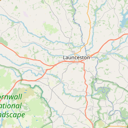
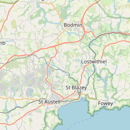
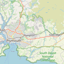


Leaflet | © OpenStreetMap contributors
Search distance between two cities
The weather for Doddycross in the United Kingdom
Get today and tomorrow's weather forecasts for Doddycross. Find out the weather forecast for the week ahead and the weekend for Doddycross in the UK.Doddycross weather forecast 15 days
What is the nearest train station to Doddycross?
List of Railway Stations near to DoddycrossThe nearest railway stations to Doddycross are listed below. Tickets are available at the train station ticket office or ticket machines.
| Name | Distances from Doddycross |
|---|---|
| Menheniot Station | 1.85 Km |
| St.Keyne Wishing Well Halt Station | 5.55 Km |
| Liskeard Station | 5.93 Km |
| Causeland Station | 6.49 Km |
| Coombe Junction Halt Station | 6.76 Km |
| St.Germans Station | 7.26 Km |
| Sandplace Station | 7.69 Km |
| Looe Station | 9.78 Km |
| Saltash Station | 13.04 Km |
| Bere Alston Station | 14.38 Km |
What is the nearest Public Transport Stops to Doddycross?
List of Stops near to DoddycrossGetting there by public transport (nearest train, tube, overground line station and bus stops). The nearest stops to Doddycross are listed below.
| Stop Name | Distances from Doddycross |
|---|---|
| Shelter Bus Stop (SE-bound) | 101 m |
| Shelter Bus Stop (NW-bound) | 132 m |
| Bodway Farm Bus Stop (E-bound) | 1.00 Km |
| Hartmeade Bus Stop (SE-bound) | 1.57 Km |
| Church Bus Stop (S-bound) | 1.79 Km |
| Church Bus Stop (N-bound) | 1.81 Km |
| Menheniot Rail Station (Entrance) | 1.85 Km |
| Menheniot Rail Station | 1.85 Km |
| Castle Motors Bus Stop (opp) | 2.02 Km |
| Hayloft Restaurant Bus Stop (NE-bound) | 2.11 Km |
Historic Places to Visit near Doddycross
List of Historic places near to Doddycross
| Name | Distances from Doddycross |
|---|---|
| Port Eliot | 6.97 Km |
| St Germans Priory Church | 7.01 Km |
| Ken-Caro Garden | 7.04 Km |
| Duloe Holy Well (St Cubys Well) | 7.71 Km |
| Duloe Stone Circle | 7.96 Km |
| Trethevy Quoit | 7.99 Km |
| Duloe, St Cubys Church | 8.16 Km |
| King Donierts Stone | 9.45 Km |
| Longstone Cross (Long Tom) | 9.67 Km |
| Looe Bay | 9.70 Km |
| Dupath Well | 9.84 Km |
| Looe Old Guildhall Museum & Gaol | 10.30 Km |
| Golitha Falls | 10.36 Km |
| Looe, St Nicholas Church | 10.38 Km |
| The Hurlers Stone Circles | 10.57 Km |
| Cheesewring | 11.25 Km |
| Cotehele Mill | 12.63 Km |
| Antony House | 12.73 Km |
| Porfell Wildlife Park | 13.15 Km |
| St Neot Church | 13.15 Km |
| Cotehele | 13.25 Km |
| Cotehele, Chapel in the Woods | 13.48 Km |
Cities or Towns near Doddycross
List of places near to
| Name | Distance |
|---|---|
| Menheniot | 1.80 Km |
| Trehunist | 2.00 Km |
| Tilland | 2.10 Km |
| Lower Clicker | 2.12 Km |
| Cutmere | 2.63 Km |
| Quethiock | 2.66 Km |
| Roseland | 3.27 Km |
| Bethany | 3.38 Km |
| Budge's Shop | 3.41 Km |
| Parson's Park | 3.43 Km |
| Horningtops | 3.68 Km |
| Pengover Green | 3.82 Km |
| Blunts | 3.82 Km |
| Tideford Cross | 4.03 Km |
| Trerulefoot | 4.08 Km |
| Merrymeet | 4.71 Km |
| Tideford | 4.75 Km |
| Widegates | 4.77 Km |
| Hessenford | 4.83 Km |
| Shortacross | 4.86 Km |
| St Ive | 4.96 Km |
| St Ive Cross | 4.99 Km |
| Parkfield | 5.15 Km |
| Hendrabridge | 5.16 Km |
| Trewidland | 5.45 Km |
| Addington | 5.55 Km |
| Trembraze | 5.64 Km |
| Trelowia | 5.70 Km |
| Higher Keason | 5.80 Km |
| Wringworthy | 5.81 Km |
| Liskeard | 5.89 Km |
| Lamellion | 6.14 Km |
| Gang | 6.24 Km |
| No Man's Land | 6.32 Km |
| Pillaton | 6.33 Km |
| Torwell | 6.42 Km |
| St Keyne | 6.49 Km |
| Narkurs | 6.59 Km |
| St Germans | 6.71 Km |
| Rosecraddoc | 6.71 Km |
| Polbathic | 6.79 Km |
| Deviock | 6.79 Km |
| Tregarland | 6.91 Km |
| Morval | 6.91 Km |
| Landrake | 7.10 Km |
| Newbridge | 7.12 Km |
| Moorswater | 7.18 Km |
| Charaton Cross | 7.24 Km |
| Looe Mills | 7.36 Km |
| St Erney | 7.37 Km |