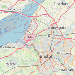
Crew's Hole Map, Satellite view of Crew's Hole, Bristol, England
Crew's Hole is located in Bristol County, City of Bristol, South West, England, United Kingdom.
Location informations of Crew's Hole
Latitude of city of Crew's Hole is 51.45377 and longitude of city of Crew's Hole is -2.53608. Crew's Hole has 1 postcode / zip code, in county of Bristol.The County of Crew's Hole is Bristol.
Postcode / zip code of Crew's Hole
BS5 8Administrative division of Crew's Hole
County :BristolGPS coordinates of Crew's Hole
Latitude : 51.45377Longitude : -2.53608
Online Map of Crew's Hole - road map, satellite view and street view


Leaflet | © OpenStreetMap contributors
Search distance between two cities
The weather for Crew's Hole in the United Kingdom
Get today and tomorrow's weather forecasts for Crew's Hole. Find out the weather forecast for the week ahead and the weekend for Crew's Hole in the UK.Crew's Hole weather forecast 15 days
What is the nearest train station to Crew's Hole?
List of Railway Stations near to Crew's HoleThe nearest railway stations to Crew's Hole are listed below. Tickets are available at the train station ticket office or ticket machines.
| Name | Distances from Crew's Hole |
|---|---|
| Lawrence Hill Station | 2.02 Km |
| Stapleton Road Station | 2.59 Km |
| Bristol Temple Meads Station | 3.18 Km |
| Montpelier Station | 3.99 Km |
| Bedminster Station | 4.30 Km |
| Redland Station | 4.66 Km |
| Keynsham Station | 4.87 Km |
| Clifton Down Station | 5.38 Km |
| Parson Street Station | 5.46 Km |
| Filton Abbey Wood Station | 5.98 Km |
Bristol Filton Airport , UK (8.22 Km)
Bristol Airport , UK (14.95 Km)
What is the nearest Public Transport Stops to Crew's Hole?
List of Stops near to Crew's HoleGetting there by public transport (nearest train, tube, overground line station and bus stops). The nearest stops to Crew's Hole are listed below.
| Stop Name | Distances from Crew's Hole |
|---|---|
| Wootton Crescent Bus Stop (W-bound) | 460 m |
| Wootton Crescent Bus Stop (E-bound) | 485 m |
| Ripon Road Bus Stop (N-bound) | 551 m |
| Troopers Hill Road Bus Stop (NW-bound) | 554 m |
| Troopers Hill Road Bus Stop (SE-bound) | 566 m |
| Marling Road Bus Stop (W-bound) | 575 m |
| Ripon Road Bus Stop (S-bound) | 594 m |
| Marling Road Bus Stop (E-bound) | 597 m |
| Harcourt Avenue Bus Stop (NW-bound) | 643 m |
| Harcourt Avenue Bus Stop (SE-bound) | 666 m |
Historic Places to Visit near Crew's Hole
List of Historic places near to Crew's Hole
| Name | Distances from Crew's Hole |
|---|---|
| Hanham Court | 3.35 Km |
| Bristol, St Pauls Church | 3.48 Km |
| St Mary Redcliffe, Bristol | 3.76 Km |
| Bristol, St Thomas the Martyr | 3.82 Km |
| Bristol, St John on the Wall Church | 4.06 Km |
| Red Lodge Museum | 4.45 Km |
| Bristols Georgian House Museum | 4.66 Km |
| Bristol City Museum and Art Gallery | 5.58 Km |
| Westbury College Gatehouse | 7.26 Km |
| Blaise Hamlet | 9.12 Km |
| Pensford, St Thomas Becket Church | 9.57 Km |
| Sir Bevil Grenville Monument | 9.59 Km |
| Kings Weston House | 9.71 Km |
| Stanton Drew Stone Circles | 9.90 Km |
| Dyrham Park | 11.77 Km |
| Dyrham Camp Hillfort | 11.93 Km |
| Beckfords Tower | 12.11 Km |
| Tyntesfield | 12.20 Km |
| No 1 Royal Crescent | 13.87 Km |
| Museum of Bath at Work | 14.10 Km |
| Bath Assembly Rooms | 14.19 Km |
| Fashion Museum, Bath | 14.20 Km |
| Jane Austen Centre | 14.25 Km |
| Museum of Bath Architecture | 14.28 Km |
| William Herschel Museum | 14.30 Km |
| Bath Postal Museum | 14.54 Km |
| Victoria Art Gallery | 14.64 Km |
| The Roman Baths | 14.64 Km |
| Sally Lunns House | 14.75 Km |
| Holburne Museum of Art | 14.91 Km |
Cities or Towns near Crew's Hole
List of places near to
| Name | Distance |
|---|---|
| St Anne's Park | 0.53 Km |
| Conham | 0.78 Km |
| Kingswood | 0.83 Km |
| Whiteway | 1.04 Km |
| Jeffries Hill | 1.04 Km |
| St Anne's | 1.08 Km |
| Netham | 1.15 Km |
| St George | 1.20 Km |
| Crofts End | 1.40 Km |
| Redfield | 1.41 Km |
| Broom Hill | 1.44 Km |
| Burchells Green | 1.52 Km |
| Whitehall | 1.53 Km |
| Hanham | 1.54 Km |
| Two Mile Hill | 1.70 Km |
| Speedwell | 1.72 Km |
| Clay Hill | 1.72 Km |
| Potterswood | 1.72 Km |
| Chester Park | 1.80 Km |
| Russell Town | 1.84 Km |
| Rose Green | 1.92 Km |
| Lower Easton | 1.97 Km |
| Moorfields | 1.98 Km |
| Clay Bottom | 2.03 Km |
| St Philip's Marsh | 2.03 Km |
| Barton Hill | 2.09 Km |
| Ridgeway | 2.14 Km |
| Arno's Vale | 2.15 Km |
| Mayfield Park | 2.26 Km |
| Upper Easton | 2.31 Km |
| Mount Hill | 2.32 Km |
| Upper Eastville | 2.32 Km |
| Brislington | 2.34 Km |
| Kensington Park | 2.36 Km |
| Hillfields | 2.59 Km |
| The Dings | 2.66 Km |
| Stone Hill | 2.71 Km |
| Hopewell Hill | 2.79 Km |
| Upper Knowle | 2.82 Km |
| Eastville | 2.83 Km |
| Hanham Green | 2.90 Km |
| Woodstock | 2.91 Km |
| Newtown | 2.99 Km |
| Upper Soundwell | 3.13 Km |
| Fishponds | 3.13 Km |
| Knowle | 3.22 Km |
| Stapleton | 3.32 Km |
| New Cheltenham | 3.32 Km |
| Warmley Hill | 3.41 Km |
| Totterdown | 3.43 Km |