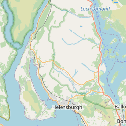
Cartsburn Map, Satellite view of Cartsburn, Renfrewshire, Scotland
Cartsburn is located in Renfrewshire County, Inverclyde, Scotland, Scotland, United Kingdom.
Location informations of Cartsburn
Latitude of city of Cartsburn is 55.94518 and longitude of city of Cartsburn is -4.73790. Cartsburn has 1 postcode / zip code, in county of Renfrewshire.The County of Cartsburn is Renfrewshire.
Postcode / zip code of Cartsburn
PA15 1Administrative division of Cartsburn
County :RenfrewshireGPS coordinates of Cartsburn
Latitude : 55.94518Longitude : -4.73790
Online Map of Cartsburn - road map, satellite view and street view


Leaflet | © OpenStreetMap contributors
Search distance between two cities
The weather for Cartsburn in the United Kingdom
Get today and tomorrow's weather forecasts for Cartsburn. Find out the weather forecast for the week ahead and the weekend for Cartsburn in the UK.Cartsburn weather forecast 15 days
What is the nearest train station to Cartsburn?
List of Railway Stations near to CartsburnThe nearest railway stations to Cartsburn are listed below. Tickets are available at the train station ticket office or ticket machines.
| Name | Distances from Cartsburn |
|---|---|
| Cartsdyke Station | 512 m |
| Greenock Central Station | 917 m |
| Whinhill Station | 933 m |
| Greenock West Station | 1.88 Km |
| Bogston Station | 1.88 Km |
| Drumfrochar Station | 2.34 Km |
| Port Glasgow Station | 3.26 Km |
| Fort Matilda Station | 3.89 Km |
| Branchton Station | 4.12 Km |
| Gourock Station | 5.26 Km |
What is the nearest Public Transport Stops to Cartsburn?
List of Stops near to CartsburnGetting there by public transport (nearest train, tube, overground line station and bus stops). The nearest stops to Cartsburn are listed below.
| Stop Name | Distances from Cartsburn |
|---|---|
| Clyde Port Authority Bus Stop (opp) | 207 m |
| Cigna Healthcare Bus Stop (opp) | 232 m |
| Clyde Port Authority Bus Stop (at) | 268 m |
| Belville Street Bus Stop (before) | 273 m |
| Belville Street Bus Stop (after) | 292 m |
| Knowe Road Bus Stop (opp) | 322 m |
| St Lawrence Street Bus Stop (opp) | 334 m |
| Knowe Road Bus Stop (after) | 342 m |
| St Lawrence Street Bus Stop (at) | 344 m |
| Arthur Street Bus Stop (opp & before) | 355 m |
Historic Places to Visit near Cartsburn
List of Historic places near to Cartsburn
| Name | Distances from Cartsburn |
|---|---|
| Newark Castle, Glasgow | 3.91 Km |
| Geilston Garden | 4.85 Km |
| Finlaystone House & Garden | 7.57 Km |
| Hill House | 8.07 Km |
| Dumbarton Castle | 11.04 Km |
Cities or Towns near Cartsburn
List of places near to
| Name | Distance |
|---|---|
| Cartsdyke | 0.59 Km |
| Charing Cross | 0.65 Km |
| Bridgend | 0.78 Km |
| Ladyburn | 1.16 Km |
| Maukinhill | 1.22 Km |
| Greenock | 1.25 Km |
| Gibshill | 1.70 Km |
| Bogston | 1.93 Km |
| Cornhaddock | 1.96 Km |
| Central | 2.09 Km |
| Chapleton | 2.31 Km |
| Overton | 2.32 Km |
| Lilybank | 2.41 Km |
| Cowdenknowes | 2.41 Km |
| Greenock West | 2.68 Km |
| Bow Farm | 2.91 Km |
| Barr's Cottage | 2.93 Km |
| Penny Fern | 3.18 Km |
| Port Glasgow | 3.20 Km |
| Gateside | 3.28 Km |
| Glen Huntly | 3.33 Km |
| North Auchneagh | 3.56 Km |
| Whitecroft | 3.64 Km |
| Fyfe Shore | 3.66 Km |
| Lyle Hill | 3.71 Km |
| Fort Matilda | 3.89 Km |
| Smithston | 4.06 Km |
| Fancy Farm | 4.19 Km |
| Devol | 4.26 Km |
| Branchton | 4.33 Km |
| Cardwell Bay | 4.38 Km |
| Coves | 4.40 Km |
| Boglestone | 4.66 Km |
| Kelhurn | 4.67 Km |
| Ravenscraig | 4.76 Km |
| Coppermine | 4.95 Km |
| Spango | 4.96 Km |
| Kelburn | 5.00 Km |
| High Carnegie | 5.14 Km |
| Braeside | 5.19 Km |
| Gourock | 5.33 Km |
| Mid Auchinleck | 5.37 Km |
| Colgrain | 5.44 Km |
| Geilston | 5.47 Km |
| Slaemuir | 5.48 Km |
| Bardrainney | 5.48 Km |
| Broadfield | 5.49 Km |
| Cardross | 5.61 Km |
| Midton | 5.61 Km |
| Woodhall | 5.65 Km |