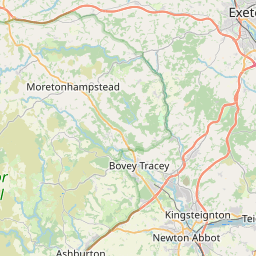
Bennah Map, Satellite view of Bennah, Devon, England
Bennah is located in Devon County, Teignbridge District, South West, England, United Kingdom.
Location informations of Bennah
Latitude of city of Bennah is 50.64850 and longitude of city of Bennah is -3.64920. Bennah has 1 postcode / zip code, in county of Devon.The County of Bennah is Devon.
Postcode / zip code of Bennah
EX6 7Administrative division of Bennah
County :DevonGPS coordinates of Bennah
Latitude : 50.64850Longitude : -3.64920
Online Map of Bennah - road map, satellite view and street view


Leaflet | © OpenStreetMap contributors
Search distance between two cities
The weather for Bennah in the United Kingdom
Get today and tomorrow's weather forecasts for Bennah. Find out the weather forecast for the week ahead and the weekend for Bennah in the UK.Bennah weather forecast 15 days
What is the nearest train station to Bennah?
List of Railway Stations near to BennahThe nearest railway stations to Bennah are listed below. Tickets are available at the train station ticket office or ticket machines.
| Name | Distances from Bennah |
|---|---|
| Exeter St. Thomas Station | 10.90 Km |
| Exeter St. David's Station | 11.68 Km |
| Exeter Central Station | 11.91 Km |
| St.James' Park Station | 12.84 Km |
| Topsham Station | 13.68 Km |
| Newton Abbot Station | 13.69 Km |
| Polsloe Bridge Station | 13.87 Km |
| Newcourt Station | 13.93 Km |
| Digby and Sowton Station | 14.36 Km |
| Starcross Station | 14.39 Km |
What is the nearest Public Transport Stops to Bennah?
List of Stops near to BennahGetting there by public transport (nearest train, tube, overground line station and bus stops). The nearest stops to Bennah are listed below.
| Stop Name | Distances from Bennah |
|---|---|
| Church Bus Stop (opp) | 490 m |
| Church Bus Stop (E-bound) | 497 m |
| School Bus Stop (S-bound) | 741 m |
| School Bus Stop (opp) | 780 m |
| Ashton Bridge Bus Stop (S-bound) | 918 m |
| Ashton Bridge Bus Stop (N-bound) | 919 m |
| Post Office Bus Stop (E-bound) | 986 m |
| Post Office Bus Stop (opp) | 1.00 Km |
| Post Box Bus Stop (E-bound) | 2.10 Km |
| Post Box Bus Stop (W-bound) | 2.11 Km |
Historic Places to Visit near Bennah
List of Historic places near to Bennah
| Name | Distances from Bennah |
|---|---|
| Ugbrooke Park | 7.62 Km |
| Hound Tor Deserted Medieval Village | 10.53 Km |
| Exeter Old Bridge | 11.18 Km |
| The House that Moved | 11.32 Km |
| Tuckers Hall | 11.36 Km |
| Cricklepit Mill | 11.36 Km |
| Exeter Custom House | 11.44 Km |
| Quay House | 11.45 Km |
| St Nicholas Priory | 11.48 Km |
| Exeter, St Olaves Church | 11.51 Km |
| Exeter Guildhall | 11.75 Km |
| Exeter, St Pancras Church | 11.75 Km |
| Exeter, St Martins Church | 11.85 Km |
| Exeters Underground Passages | 11.90 Km |
| St Catherines Almshouses & Canons House | 11.95 Km |
| Kenton, All Saints Church | 12.32 Km |
| Castle Drogo | 12.65 Km |
| Powderham Castle | 13.17 Km |
| Bradley Manor House | 13.69 Km |
| Grimspound | 13.83 Km |
| West Ogwell Church | 13.88 Km |
| Widecombe-in-the-Moor, St Pancras Church | 13.91 Km |
| Church House | 13.96 Km |
| Newton St Cyres, St Cyr and St Julittas Church | 14.18 Km |
Cities or Towns near Bennah
List of places near to
| Name | Distance |
|---|---|
| Coombe | 0.57 Km |
| Christow | 0.77 Km |
| Lower Ashton | 0.99 Km |
| Court Barton | 1.00 Km |
| Higher Ashton | 2.11 Km |
| Bridford | 2.64 Km |
| Doddiscombsleigh | 2.93 Km |
| Bridfordmills | 3.00 Km |
| Trusham | 3.07 Km |
| Teign Village | 3.51 Km |
| Hennock | 3.75 Km |
| Sowton Barton | 4.00 Km |
| Hawkmoor Park | 4.81 Km |
| Dunchideock | 5.07 Km |
| Underdown | 5.08 Km |
| Reedy | 5.10 Km |
| Westcott | 5.19 Km |
| Dunsford | 5.54 Km |
| Wreyland | 5.82 Km |
| Chudleigh | 5.93 Km |
| Lustleigh | 5.97 Km |
| Doccombe | 6.24 Km |
| Bovey Tracey | 6.33 Km |
| Clapham | 6.58 Km |
| Longdown | 6.91 Km |
| Bilsdon | 7.07 Km |
| Chudleigh Knighton | 7.15 Km |
| Holcombe Burnell | 7.45 Km |
| Lustleigh Cleave | 7.60 Km |
| Gappah | 7.61 Km |
| Shillingford St George | 7.73 Km |
| Olchard | 8.06 Km |
| Kennford | 8.07 Km |
| Brimley | 8.25 Km |
| Moretonhampstead | 8.27 Km |
| Kenn | 8.52 Km |
| Shillingford Abbot | 8.64 Km |
| Heathfield | 8.65 Km |
| Pathfinder Village | 8.70 Km |
| Green Lane | 9.03 Km |
| Ide | 9.04 Km |
| Manaton | 9.10 Km |
| Ideford | 9.20 Km |
| Ashcombe | 9.23 Km |
| North Bovey | 9.51 Km |
| Whitestone | 9.62 Km |
| Liverton | 9.78 Km |
| Ilsington | 9.80 Km |
| Coldeast | 9.82 Km |
| Halsfordwood | 9.84 Km |