Barr Common Map, Satellite view of Barr Common, West Midlands, England
Barr Common is located in West Midlands County, Walsall District, West Midlands, England, United Kingdom.
Location informations of Barr Common
Latitude of city of Barr Common is 52.59389 and longitude of city of Barr Common is -1.91320. Barr Common has 1 postcode / zip code, in county of West Midlands.The County of Barr Common is West Midlands.
Postcode / zip code of Barr Common
WS9 0Administrative division of Barr Common
County :West MidlandsGPS coordinates of Barr Common
Latitude : 52.59389Longitude : -1.91320
Online Map of Barr Common - road map, satellite view and street view
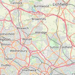

Leaflet | © OpenStreetMap contributors
Search distance between two cities
The weather for Barr Common in the United Kingdom
Get today and tomorrow's weather forecasts for Barr Common. Find out the weather forecast for the week ahead and the weekend for Barr Common in the UK.Barr Common weather forecast 15 days
What is the nearest train station to Barr Common?
List of Railway Stations near to Barr CommonThe nearest railway stations to Barr Common are listed below. Tickets are available at the train station ticket office or ticket machines.
| Name | Distances from Barr Common |
|---|---|
| Blake Street Station | 4.77 Km |
| Walsall Station | 4.95 Km |
| Butlers Lane Station | 5.08 Km |
| Four Oaks Station | 5.96 Km |
| Tame Bridge Parkway Station | 6.23 Km |
| Bescot Stadium Station | 6.28 Km |
| Sutton Coldfield Station | 6.78 Km |
| Shenstone Station | 6.87 Km |
| Hamstead Station | 7.07 Km |
| Bloxwich Station | 7.17 Km |
What is the nearest Public Transport Stops to Barr Common?
List of Stops near to Barr CommonGetting there by public transport (nearest train, tube, overground line station and bus stops). The nearest stops to Barr Common are listed below.
| Stop Name | Distances from Barr Common |
|---|---|
| Knights Hill Bus Stop (opp) | 15 m |
| Knights Hill Bus Stop (adj) | 29 m |
| Beacon Rise Bus Stop (adj) | 356 m |
| Beacon Rise Bus Stop (opp) | 363 m |
| Churnhill Rd Bus Stop (adj) | 502 m |
| Barr Common Rd Bus Stop (after) | 534 m |
| Barr Common Rd Bus Stop (before) | 550 m |
| Churnhill Rd Bus Stop (opp) | 554 m |
| St Francis School Bus Stop (adj) | 572 m |
| St Francis School Bus Stop (opp) | 608 m |
Historic Places to Visit near Barr Common
List of Historic places near to Barr Common
| Name | Distances from Barr Common |
|---|---|
| Wall Roman Site (Letocetum Baths and Museum) | 7.92 Km |
| Bilston Craft Gallery | 11.04 Km |
| Birmingham Back to Backs | 13.33 Km |
| Black Country Living Museum | 13.48 Km |
| Moseley Old Hall | 13.66 Km |
| Wolverhampton Art Gallery | 14.44 Km |
Cities or Towns near Barr Common
List of places near to
| Name | Distance |
|---|---|
| Bourne Vale | 1.15 Km |
| Aldridge | 1.31 Km |
| Hardwick | 1.95 Km |
| Mill Green | 2.13 Km |
| Stubber's Green | 2.43 Km |
| Leighswood | 2.45 Km |
| Streetly | 2.66 Km |
| Daw End | 2.76 Km |
| Little Aston | 3.27 Km |
| Vigo | 3.44 Km |
| Holly Bank | 3.45 Km |
| Rushall | 3.57 Km |
| Shelfield | 3.64 Km |
| The Chuckery | 3.79 Km |
| Streetly | 3.85 Km |
| Walsall Wood | 4.08 Km |
| Pheasey | 4.12 Km |
| Thornes | 4.13 Km |
| Coal Pool | 4.25 Km |
| Banners Gate | 4.26 Km |
| Hill Hook | 4.27 Km |
| Stonnall | 4.33 Km |
| Ryecroft | 4.37 Km |
| Heath End | 4.55 Km |
| Four Oaks | 4.56 Km |
| Walsall | 4.61 Km |
| Old Oscott | 4.84 Km |
| Queslett | 4.85 Km |
| Lower Stonnall | 4.85 Km |
| Shire Oak | 4.92 Km |
| Harden | 4.95 Km |
| Hill | 4.99 Km |
| Goscote | 5.05 Km |
| Great Barr | 5.12 Km |
| Caldmore | 5.16 Km |
| Yew Tree | 5.21 Km |
| Palfrey | 5.22 Km |
| Lynn | 5.29 Km |
| Pelsall | 5.32 Km |
| Ladywood | 5.35 Km |
| Footherley | 5.39 Km |
| Catshill | 5.45 Km |
| The Delves | 5.46 Km |
| Kingstanding | 5.48 Km |
| Birchills | 5.50 Km |
| Shenstone Woodend | 5.53 Km |
| Watford Gap | 5.58 Km |
| Mere Green | 5.69 Km |
| Ley Hill | 5.71 Km |
| Grove Vale | 5.75 Km |